LiDAR Data Production
- Home
- LiDAR Data Production
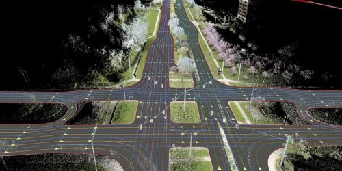
LiDAR survey is a technology that uses laser pulse to hit the target and estimates the distance by the time of the returning pulse. We have a specialized LiDAR team who can handle data acquisition and also LiDAR data processing. We are sound in the data collection techniques using 3D laser scanner and MLS (Mobile LiDAR Scanner).
LiDAR (Light Detection and Ranging) is a technology that uses laser pulses to create detailed 3D maps of the environment. LiDAR data protection refers to the measures taken to safeguard the privacy and security of the data generated by LiDAR systems. As LiDAR data contains information about the physical characteristics of the environment and the objects within it, it can be sensitive and valuable information. For example, it can reveal the layout of buildings, the location of critical infrastructure, or the movement of people and vehicles. As such, protecting LiDAR data from unauthorized access, use, or disclosure is essential. To protect LiDAR data, various measures can be taken, such as encryption, access controls, and data anonymization. Encryption involves using algorithms to convert the data into an unreadable format, which can only be accessed with a key or password.
Privacy and Security of LiDAR Data
Encryption: LiDAR data can be encrypted using symmetric or asymmetric encryption algorithms to protect it from unauthorized
Access Controls: Access controls are measures that limit who can access LiDAR data and what they can do with it.
Data Anonymization: Data anonymization is the process of removing personally identifiable information from LiDAR data to protect privacy.
Data Storage and Retention: LiDAR data should be stored securely to prevent unauthorized access, loss, or corruption.
Data Sharing: LiDAR data should only be shared with authorized users and organizations.
Data Destruction: LiDAR data should be destroyed when it is no longer needed or when it is no longer authorized to be stored