Photogrammetry
- Home
- Photogrammetry
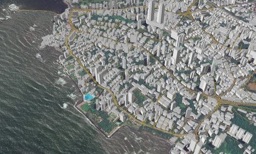
Photogrammetry deals with acquiring imageries of the Earth’s surface and carrying out analysis with the data. Our team expertise in feature extraction, 3D modelling in the required LoD (Level of Detail) and reality capturing. Photogrammetry is the science of obtaining reliable measurements and information about the physical properties of objects and their environment using photographs. This technique involves taking multiple overlapping images of an object or scene from different angles, and then processing these images to create a 3D model or map of the object or environment. Photogrammetry has a wide range of applications, including land surveying, cartography, archaeology, geology, forestry, civil engineering, and many others. It is particularly useful in cases where direct measurements are difficult or impossible to obtain. The process of photogrammetry involves various steps, including image acquisition, image preprocessing, image matching, 3D reconstruction, and data analysis. The accuracy and reliability of photogrammetric results depend on various factors such as camera calibration, image quality, and the availability of control points. With the advent of advanced digital cameras and software, photogrammetry has become more accessible and widely used in many fields.
Photogrammetry Stages
Image Acquisition: The first step in photogrammetry is to capture a series of overlapping photographs of
the object or scene of interest using a camera or drone.
Image Preprocessing: The next step is to preprocess the images to remove any distortion, noise, or
artifacts that might affect the accuracy of the results.
Image Matching: The images are then processed to identify corresponding points and features that can
be used to create a 3D model.
3D Reconstruction: Once the corresponding points have been identified, the images are used to create a
3D model of the object or scene.
Data Analysis: Finally, the 3D model is analyzed to obtain the desired measurements and information.