

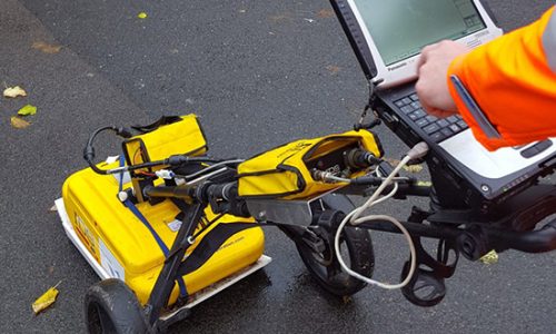
GPR Survey (Ground Penetrating Radar Survey) is a non-destructive geophysical method that uses radar pulses to image the subsurface. It is commonly used to investigate the subsurface structures and materials, including soils, rock, concrete, and ice. We offers the sophisticated service of GPR survey and also underground feature detection from the hyperbolas. GPR survey involves, focusing electromagnetic pulses (radar signals) of short duration into the ground using a specialized antenna. The signals propagate and are then reflected by discontinuities or interfaces in soil materials and return to be detected by a receiver antenna. The GPR equipment sends high-frequency electromagnetic waves into the ground and records the reflections that bounce back to the surface. By analyzing the reflected signals, GPR can provide a 2D or 3D image of the subsurface, showing the location and characteristics of buried objects, layers, and anomalies. GPR Survey has a wide range of applications, such as utility detection, archaeological investigation, environmental assessment, geotechnical investigation, and pavement analysis. It is a versatile, fast, and cost-effective tool for subsurface imaging, and it can be used in a variety of field conditions, including urban areas, remote locations, and hazardous sites.
How it works: GPR emits electromagnetic waves into the ground and measures the time it takes for the waves to bounce back. The reflected signals are then processed to create a 2D or 3D image of the subsurface. The depth of the imaging depends on the frequency of the waves, with higher frequencies providing shallower imaging but better resolution.
Applications: GPR Survey has numerous applications in various fields. For example, it can be used to locate buried utilities, such as pipes and cables, for construction and excavation purposes. It can also be used in geotechnical investigations to assess soil and rock conditions, in environmental assessments to detect underground storage tanks and contaminated soils, and in archaeological investigations to locate buried structures and artifacts.
Advantages: GPR Survey has several advantages over other geophysical methods. It is non-invasive, meaning it does not require drilling or excavation to obtain subsurface information. It is also fast, allowing for large areas to be surveyed quickly. Additionally, it is relatively inexpensive compared to other subsurface imaging methods.