

LiDAR is an advanced survey technology which scans the features in the area of interest with the highest accuracy point clouds. The instrument does a 360 ° scan of the area as a point clouds. The application of terrestrial scanner is endless. The data obtained using this LiDAR technology recreates the original features into the As-built form with high accuracy. The data can be used for precise measurement and planning and completely solves the shortcomings faced by traditional technologies. The terrestrial laser scanning technology is cost effective and saves ample amount of time. Lidar (Light Detection and Ranging) scanning is a technology that uses laser beams to create precise 3D digital models of physical objects and environments. It works by emitting a laser beam from a device and measuring the time it takes for the beam to bounce back after hitting an object. The device then uses this information to create a 3D map of the object or environment being scanned. Lidar scanning is commonly used in various industries such as construction, architecture, surveying, mapping, and autonomous vehicles. It enables the creation of highly detailed and accurate models of physical spaces, which can be used for a variety of purposes such as planning and design, analysis, and visualization. The technology has evolved over the years and has become more affordable and accessible, with handheld and portable Lidar scanners now available for use in various settings.
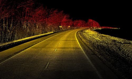
The use of a device called a Lidar sensor, which emits laser beams at a high frequency and measures the time it takes for the beams to reflect back from surrounding objects. The sensor captures millions of data points per second, creating a highly detailed point cloud that represents the 3D geometry of the scanned environment. The Lidar sensor can be mounted on a tripod or vehicle to capture data from various angles and distances. The data collected can be processed using specialized software to create a 3D model of the environment or object being scanned. The resulting model can be viewed, edited, and analyzed using a variety of software tools. One of the key advantages of Lidar scanning is its ability to capture highly accurate and detailed data. Lidar sensors can detect even small variations in surfaces and provide a precise representation of the environment being scanned. This level of detail makes Lidar scanning useful in various applications, such as construction, surveying, and mapping.